Description
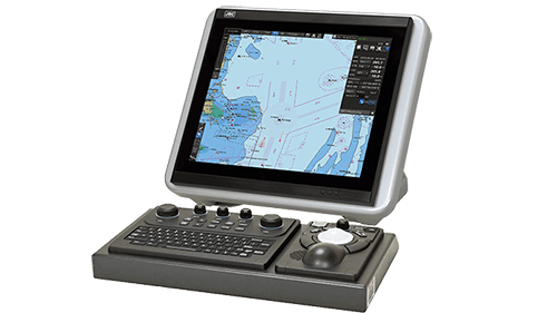
ECDIS
The Electronic Chart Display and Information System (ECDIS) is a geographic information system for voyage planning and route monitoring to support the safety navigation of ships at sea. And in response to the latest revision of the International Convention for the Safety of Life at Sea (SOLAS), the International Maritime Organization (IMO) enforced the mandatory installation of the ECDIS by July 2017 according to vessel’s category.(Requirements for the equipment and operation qualification are subject to approval from the country with which the ship is registered and recommendations from the classification society of the ship.)
The ECDIS onboard a ship uses information from the automatic identification system (AIS) and superposes the images with navigational chart information, thus accurately displaying dynamic information on other ships around. Also the ECDIS plays central roles in the safe navigation of the ship and provides safety functions, including the generation of warnings when the ship approaches dangerous areas. The ECDIS is useful for marine accident avoidance and serves as equipment indispensable to the safe navigation of ships.
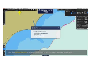
Type-specific training (TST)
Unlike JRC’s conventional ECDIS models, this ECDIS has adopted a new operation system and a TST program supporting the new operation system is required. The TST for the new ECDIS is given at JRC’s major branches, agents, and training institutions around the world. The training will be given onboard or offices by instructors dispatched at the request of customers. Furthermore, PC software is available for users’ self-learning at home or onboard. For more information about TST, contact your JRC representative.
Spesification :
Specs
| Model | 19-inch model | JAN-7201S |
|---|---|---|
| 26-inch model | JAN-9201S | |
| Conforming to IMO standards | ✓ | |
| Hardware function | ||
| Display unit | JAN-7201S: 19-inch SXGA color LCD, 1280 × 1024 pixels JAN-9201S: 26-inch WUXGA color LCD, 1920 × 1200 pixels | |
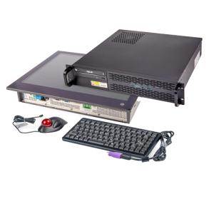
| Central control block | Intel Core i5 2515E 2.5GHz 2GB main memory SSD × 2 DVD drive × 1 | |
| Power supply | 24V DC and single-phase 100 to 115V AC or 220 to 240 V AC at 50/60 Hz | |
| Power consumption | Rating JAN-7201S: 200 VA approx., JAN-9201S: 240 VA approx. | |
| Chart display function | ||
| Chart database | ENC: S-57 Ed3.0/3.1 and S-63 AVCS (AIO supported), NAVTOR ENC Service, Jeppesen ENC Service Raster charts: ARCS Personal chart: Jeppesen Ed.3 Professional / Professional+ | |
| Operation mode | TM (true motion)/RM (relative motion) display | |
| Azimuth display mode | True motion mode: North UP/Course UP/Head UP/Waypoint UP Relative motion mode: North UP/Course UP/Head UP/Waypoint UP | |
| Scale | 1:1,000 to 1:40,000,000 (SXGA) / 1:20,000,000 (WUXGA) | |
| Range | 0.125, 0.25, 0.5, 0.75, 1.5, 3, 6, 12, 24, 48, 96NM | |
| Multi-window display | Upper-lower split / Left-right split / Picture-in-picture | |
| Route planning function | ||
| Route creation | Table/Graphic editing | |
| Route editing | Waypoint addition / deletion / edition Alternative route creation Route copy Connection between routes Import / export (in CSV) | |
| Safety check | Yes | |
| Number of routes displayed | Four types max. | |
| Navigation-monitoring function | ||
| Own ship | Monitoring for position, wake, and dragging anchor | |
| Route monitoring | Water depths, obstacles, approaching prohibited areas, course deviation, waypoints, and arrival time | |
| Other ship monitoring | AIS display: 500 targets max. | |
| User map | ||
| Number of display points | 100,000 points (marks and lines) | |
| Import/Export | Possible with USB memory | |
| Other functions | ||
| Data display function | Conning data block display | |
| Self-diagnostic function | Standard | |
| Remote maintenance function | Standard | |
| Playback | Navigation data (3 months max.) Logbook (3 months max.) | |


Reviews
There are no reviews yet.