| Conforming to IMO standards | ✓ |
| Hardware function |
|---|
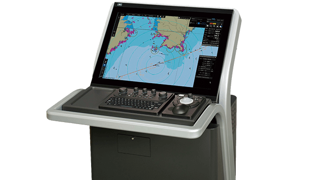
| Display unit | JAN-9201: 26-inch WUXGA color LCD, 1920 × 1200 pixels, touch panel (sold separately)
JAN-7201: 26-inch WUXGA color LCD, 1280 × 1024 pixels, touch panel (sold separately) |
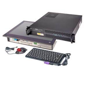
| Central control block | Intel Core i5 2515E 2.5 GHz
2-GB main memory
SSD × 2
DVD drive × 1 |
| Power supply | 24 V DC or single-phase 100 to 115V AC or 220 to 240 V AC at 50/60 Hz |
| Power consumption | Rating JAN-9201: 240 VA max.; JAN-7201: 200 VA max. |
| Chart display function |
|---|
| Chart database | ENC: S-57 Ed3.0/3.1 and S-63
AVCS (AIO supported), NAVTOR ENC Service, and Jeppesen ENC Service
Raster charts: ARCS
Personal chart: Jeppesen Ed.3 Professional/Professional+ |
| Operation mode | TM (true motion)/RM (relative motion) display |
| Azimuth display mode | True motion mode: North UP/Course UP/Head UP/Waypoint UP
Relative motion mode: North UP/Course UP/Head UP/Waypoint UP |
| Scale | 1:1,000 to 1:20,000,000 (WUXGA)/1:40,000,000 (SXGA)/1:20,000,000 (FHD) |
| Range | 0.125, 0.25, 0.5, 0.75, 1.5, 3, 6, 12, 24, 48, 96NM |
| Multi-window display | Upper-lower split/Left-right split/Picture-in-picture |
| Route planning function |
|---|
| Route creation | Table/Graphic editing |
| Route editing | Waypoint addition/deletion/edition
Alternative route creation
Route copy
Connection between routes
Import/export (in CSV) |
| Safety check | Yes |
| Number of routes displayed | Four types max. |
| Navigation-monitoring function |
|---|
| Own ship | Monitoring for position, wake, and dragging anchor |
| Route monitoring | Water depths, obstacles, approaching prohibited areas, course deviation, waypoints, and arrival time |
| Other ship monitoring | TT display 200 targets max. (100 targets per radar and responding to a maximum of two radars)
AIS display: 500 targets max. (expanding to a maximum 1,000 targets with an optional function added) |
| User map |
|---|
| Number of display points | 100,000 points (marks and lines) |
| Import/Export | Possible with USB memory |
| Other functions |
|---|
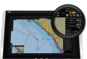
| Data display function | Conning data block display |
| Self-diagnostic function | Standard |
| Remote maintenance function | Standard |
| Playback | Navigation data (3 months max.)
Logbook (3 months max.) |
| Radar overlay | Optional (software license) |
| TCS | Optional |
| S-Joy control supported | Optional |


Reviews
There are no reviews yet.